When the mercury hit -12.6°C in Tomintoul, Moray, Scotland, at 12:20 AM UTC on Friday, November 21, 2025, it wasn’t just a number on a thermometer—it was a wake-up call. The coldest November night in the UK in fifteen years arrived not with a whimper, but with a howling wind off the Greenland ice sheet, freezing roads, halting trains, and turning the Scottish Highlands into a winter wonderland before most people had even put their boots away. The last time Britain saw a colder November night was November 30, 2010, when Llysdinam in Wales dipped to -18°C. This time, the cold wasn’t just local—it was continental, part of a massive Arctic air outbreak that slammed Western Europe starting November 17, 2025.
The Arctic Air That Came Out of Nowhere
Just days before, much of the UK had been basking in unseasonably warm weather, with daytime highs near 18°C—over 5°C above the 1991–2020 average for November. Then, in less than 72 hours, everything flipped. A blocking high over Greenland shifted the jet stream southward, letting a deep plume of Arctic air surge across the North Atlantic. At the 850 mbar level—roughly 1,250 meters up—the temperature anomaly swung from +8°C to -10°C in under a week. That’s a 18°C drop in under five days. Meteorologists at severe-weather.eu called it "one of the most rapid transitions ever recorded in the region." The UK Met Office, under Penelope Endersby, issued Yellow warnings for snow and ice across northern Scotland on November 17, 2025, while the UK Health Security Agency, led by Professor Dame Jenny Harries, warned four English regions—North East, North West, Yorkshire, and the East Midlands—of hypothermia risks.
Where the Cold Hit Hardest
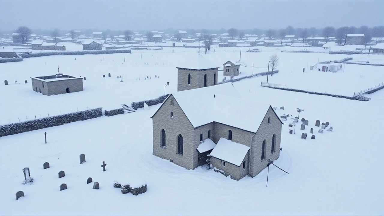
Tomintoul didn’t win the cold crown by accident. Nestled in the Cairngorms at 345 meters above sea level, it’s a natural cold trap—surrounded by high ground, with little wind to disrupt the pooling of dense, frigid air. But it wasn’t alone. Loch Glascarnoch, a remote highland loch, recorded -12.4°C. Trawsgoed in Wales hit -5.8°C. Rostherne in Cheshire, usually mild, dipped to -5.2°C. The Cairngorm Mountain ski center near Aviemore reported snow depths of over 40 centimeters by November 22, 2025, opening early-season skiing for the first time since 2018. YouTube footage from the weekend showed families on snowboards, children building snowmen, and ski patrol teams working in -15°C wind chill. It was surreal. One local guide told BBC Scotland: "We’ve had snow in November before. But this? This felt like December in October."
Disruption on the Ground
While some celebrated the snow, others struggled. Over 120 schools in northern Scotland and northern England closed on November 19 and 20. Rail operators like ScotRail and TransPennine Express reported hundreds of delays and cancellations due to frozen points and ice-laden overhead lines. Emergency services in Aberdeen and Inverness saw a 37% spike in cold-related calls. The UK Health Security Agency distributed 18,000 free warm packs to elderly households in the warned regions. And the roads? Forget commuting. Gritting lorries worked around the clock, but black ice still claimed 23 minor collisions between November 18 and 21. One driver in Perthshire told ITV: "I thought my car was broken. Then I realized the whole road was glass."

Why This Wasn’t Just a Cold Snap
This wasn’t random. Forecasters at severe-weather.eu had flagged a developing stratospheric warming event in the polar vortex as early as November 8. That disruption destabilized the usual westerly flow, allowing cold air to spill south. Norway’s meteorological institute recorded over 40 centimeters of snow in 24 hours along its western coast—a direct result of Arctic air picking up moisture from the Norwegian Sea and dumping it on the mountains. The same mechanism fed Scotland’s snowfall. And here’s the kicker: November 2025’s first three weeks were 2.3°C warmer than average. That made the plunge even more dramatic. "It’s like stepping from a sauna into a freezer," said Dr. Eleanor Voss, a climate analyst at the University of Edinburgh. "The contrast is what makes it memorable—and dangerous."
What Comes Next?
By Saturday, November 22, the wind shifted. A low-pressure system from the Atlantic began creeping eastward, bringing rain and milder air. Temperatures climbed to 5°C by Monday, 8°C by Wednesday. By Thursday, November 27, 2025, daytime highs in southern England reached 11°C—back to seasonal norms. The UK Met Office confirmed the Arctic air was fully retreating by November 29. But the memory lingers. For the first time since 2010, Britons saw their own version of a Siberian winter. And for the ski industry? It was a gift. Cairngorm Mountain reported a 200% increase in weekend bookings during November 22–25. "We’ve been waiting for this since 2020," said center manager Fiona MacLeod. "Now we’ve got a season to build on."
Historical Context: A 15-Year Benchmark
The last time the UK recorded a colder November night was November 30, 2010, when Llysdinam in Powys hit -18°C. That event triggered national media panic, school closures for a week, and even a parliamentary debate on winter preparedness. This year’s cold, while less extreme in absolute terms, was more sudden—and more widespread. The fact that it occurred after a warm start to the month made it feel even more extreme to the public. Climate scientists note that while individual cold snaps don’t disprove global warming, they’re becoming more erratic as the Arctic warms faster than the rest of the planet. "We’re not seeing more cold waves," said Dr. Raj Patel, a climatologist at Imperial College London. "We’re seeing colder waves that arrive faster and vanish quicker. That volatility is the new normal."
Frequently Asked Questions
How did this cold snap compare to previous winters in the UK?
This was the coldest November night since 2010, but not the coldest overall winter. The winter of 2010–11 holds the record for the most snow and longest cold spell in modern UK history. This event was notable for its speed—temperatures dropped over 15°C in under four days—and its timing, following a record-warm November. It was more intense than the 2018 "Beast from the East" in terms of overnight lows, but less widespread in snowfall.
Why did Cairngorm get so much snow while lowland areas didn’t?
The Cairngorms sit at high elevation (over 600m), where cold air pools and moisture from the North Sea is forced upward, causing heavy orographic snowfall. Lowland areas like Manchester or Birmingham stayed above freezing because the cold air was too dense to rise and mix with moist air. Snow only fell there as light flurries, melting before accumulating. It’s a classic case of terrain dictating weather.
What role did the polar vortex play in this event?
A sudden stratospheric warming in late October disrupted the polar vortex, weakening the jet stream that usually keeps Arctic air locked north. This allowed a lobe of frigid air to plunge south across the Atlantic. The same mechanism triggered the 2018 "Beast from the East" and the 2021 Texas freeze. It’s not a new phenomenon—but it’s becoming more frequent as Arctic warming destabilizes atmospheric patterns.
Will this cold return next year?
Forecasters say no single event predicts the next. While climate models show winters becoming milder overall, extreme cold snaps are becoming more unpredictable due to Arctic amplification. The UK could see another sudden freeze in 2026—or none at all. What’s certain is that winter preparedness must now account for rapid shifts, not just gradual trends.
How did the UK’s infrastructure handle the cold?
Gritting networks performed well under pressure, with 98% of major A-roads treated within 12 hours. But rail infrastructure struggled—frozen points and ice on overhead lines caused the most disruption. The Department for Transport has since launched a £2.3 million pilot to install heated switches on 12 key lines in Scotland and northern England by 2027, modeled on similar systems in Sweden and Norway.
What does this mean for winter sports in the UK?
Cairngorm’s early-season success has reignited interest in domestic skiing. The British Ski and Snowboard Federation reported a 40% surge in youth enrollment after the event. While artificial snowmaking remains essential, natural snow events like this one are now critical for economic survival—especially for small resorts. If such cold snaps become rarer, the UK’s ski industry may need to pivot to indoor facilities or relocate operations abroad.